São Paulo
CGH
Aeroporto de São Paulo/Congonhas

Brasil
Partidas


Chegadas
Aeroporto de São Paulo/Congonhas
Sao Paulo Congonhas Airport (CGH) serves Sao Paulo, Brazil, and lies just 5 miles from the city center, making it one of the more conveniently located airports for travelers heading into the metropolitan area. The airport sits at an elevation of 2,631 feet, a factor that can influence aircraft performance and approach procedures compared to airports closer to sea level.
Given its proximity to downtown Sao Paulo, Congonhas primarily serves as a hub for domestic and regional traffic rather than long-haul international flights, which typically route through other airports serving the metropolitan area. Its close-in location makes it a practical choice for business travelers and those on shorter regional routes within Brazil and South America, prioritizing convenience over the longer ground transfer times associated with more distant airports.
The airport's elevated position, at nearly half a mile above sea level, is a notable characteristic for pilots and airlines operating there, as it can affect takeoff and landing distances, particularly for larger aircraft. Travelers using Congonhas should note this elevation as part of the airport's distinct operating profile, which sets it apart from many other airports at lower altitudes serving similarly sized cities.
Altitude acima do nível do mar
802 m
Distância da cidade
8 km
Volume de tráfego
250 voos por dia
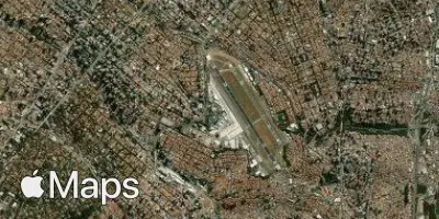
Satélite
Use a aplicação durante o voo.
Tenha a previsão do voo sempre à mão e receba atualizações dos dados com a nossa aplicação gratuita para telefone e tablet.